
Authors:
Michelle Woody
Jon Nordling
Recently there have been many inquiries regarding integration of GeoODK/ODK with ArcGIS online. Over the last few years we have been developing a simple integration process that requires minimal configuration, and we are excited to explain how this process works.
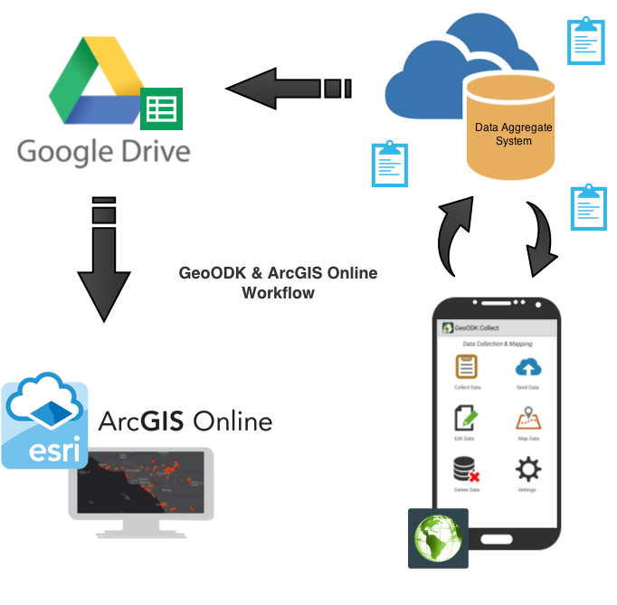
The seamless and dynamic “out of the box” integration process starts with data collected with the GeoODK Collect and ends with ArcGIS online maps. Below you will learn what you need to complete this process and an outline of the steps. This outline is for a dynamic dataset that includes a location element (geopoint).
In order to complete the process you will need an Aggregate System (such as ODK Aggregate, Formhub or Ona.io), a Google Drive account, and an ArcGIS Online account.
For demonstration purposes ODK Aggregate is the data aggregate system used throughout this blog. However similar functionality is possible with Ona.io and Formhub.
Google Drive comes standard with a Google account. This process specifically uses the spreadsheets on Google Drive as a link between aggregate data and ArcGIS online.
If you are unfamiliar with ArcGIS Online we suggest you explore what it has to offer. There is a wealth of datasets, mapping solutions, and guides useful to every project. You can learn more about the platform here.
http://www.esri.com/software/arcgis/arcgisonline
Once you have collected data it can be sent to the Aggregate System where all of your data is stored.
Example of a survey with a location data type:

Need help developing your form? Visit our Getting Started page.
**Unsure how to convert your Excel file to an aggregate and mobile ready format? See our Conversion Tutorial page.
Next, publish your data into a Google Drive Spreadsheet inside the Aggregate System. This will connect with your Google Drive account and publish the data in a spreadsheet. This will later connect with ArcGIS Online.


Once your data is published in Google Drive it will look similar to the image below.

In order to make a dynamic link between your Google spreadsheet and ArcGIS online, the sharing options must be configured as seen below.

Once your spreadsheet is uploaded and shared, modify the Google Drive share link to include the “export” and “&format-csv” as seen in the link below.
https://docs.google.com/spreadsheets/d/14gt1Ql5tDGkeOsH75yuE12y-p7-X0isA0PWJWHfnxBE/export#gid=1588173911&format=csv
This creates a dynamic link between your Google spreadsheet and ArcGIS Online.
To add your data to an ArcGIS Online map, first log in to your Arc account and create a webmap and set the layer to reference “A CSV File”, and add the Google Drive URL you modified in the step above.

Now the form/data is connected from your Aggregate System to the ArcGIS Online map. The map layers will update when additional data is added to your Aggregate system from your mobile device.
The following is a map that represents the workflow for GeoODK Collect to ArcGIS Online.
For more discussion or technical help check out


