
World Geocoder for ArcGIS allows the mapping of global addresses, all in one location. With this tool, organizations are able to convert text based addresses into mapped location data behind a firewall. True location data offers the ability to leverage spatial analysis tools to better understand customers, beyond a collection of dots on a map.
The key capabilities of World Geocoder for ArcGIS
- Interactive geocoding – with search suggestions functionality to quickly find what you’re looking for.
- Batch geocoding – Use the API (Application Programming Interface) to upload a table or spreadsheet of addresses in one go with geocodeAddresses. Developer friendly, and a tremendous time-saver!
- Reverse geocoding – for finding addresses via coordinate inputs, a useful tool for field workers.
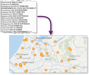
Geocoding allows you to pinpoint addresses, cities, landmarks, businesses, and other points of interest.
Display these point data in map form, create stops along a route, and run spatial analysis to learn more about your data. This tool allows you to put your data on the map, literally.
As you begin to better understand your data, you’ll gain greater insight into patterns that will help in key business decisions.
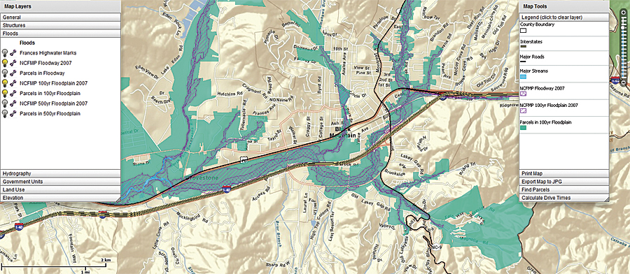
For example, insurance companies highly value geocoding capabilities for their industry. By leveraging a map visualization of all their customer location data, they gain highly valuable insight. Policy valuation based a customer’s exact location, risk assessment and mitigation determined by that customer’s surrounding area. Are they at risk of water damage because they live in a floodplain? Do they live in tornado alley? Is their home located along the coastline and subject to hurricane season?
With great power comes great responsibility
World geocoding allows businesses to provide faster services as well. Let’s consider a delivery service, with 30 packages to drop off, all at different locations. With the power of geocoding, that business can optimize their delivery route to minimize time (and gas), thus saving money and contributing to healthy business growth.
The power of geocoding has also extended into retail (to locate loyalty program members), government (to control regulated data) and in the promotion of public safety (via investigative and intelligence analysis). If you have customers, you need World Geocoder for ArcGIS.
Interested in learning how World Geocoder for ArcGIS can improve your business strategies, growth and development?
Contact our experts at support@geomarvel.com to begin implementing these powerful tools in your business today.


