
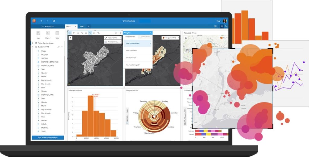
Discover more about your data with Insights for ArcGIS, a GIS tool that allows you to create iterative and exploratory data analysis. By connecting your data with the maps directly, you can use charts and tables to summarize your exact data needs, and answer all your location-based questions.
Insights for ArcGIS in 5 Steps
- Easy functionality with drag and drop analysis
- Simple visuals with all you data combined in one view
- Reveal trends, correlations, and partnerships by analyzing your data with maps, charts and graphs
- Recorded steps allow for repeat analysis workflows
- Let the data speak for itself: Design reports with text, links, images, video and branding
Use these available esri tools and guides to start your Insights for ArcGIS journey
- Free eBook to learn five ways to jumpstart your spatial analysis
- Compare visualization options based on data type
- Watch a series of videos diving deep into Insights for ArcGIS
- Explore both free and paid training courses offered from esri
- Learn how to create a workbook, add, analyze, map and manage your data
- Or start your free Insights for ArcGIS trial
Spatial Awareness in the Water Industry
Using Insights for ArcGIS, Opelika Utilities (a water utility company in Alabama) discovered a plethora of dead meters throughout their system that they did not know about previously. By finding and identifying these dead meters, they have been able to save over $25,000 per month in revenue.
By leveraging this important decision making tool, they’ve learned more from their data. And rather than running a script for 6-7 hours, Insights for ArcGIS can reveal critical data within minutes.
“It’s easy. All we have to do is get our data, do a little bit of clean up, and feed it into the program. And we’re getting answers.” – Alan Lee, Capital Projects Manager, Opelika Utilities
See More Examples of Insights for ArcGIS in Action
Get Started
Contact our GIS experts to help you start leveraging your data to its fullest potential.


