
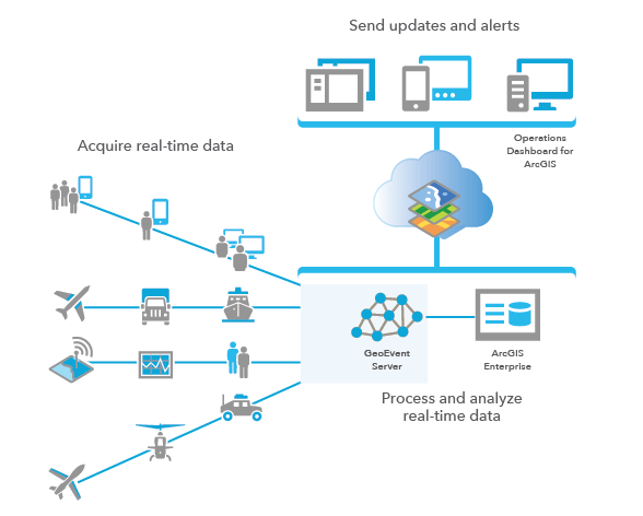
Leverage real-time mapping and analytics with ArcGIS GeoEvent Server. Monitoring big data in real-time with the power of ArcGIS Enterprise. Monitor stationary sensors (water gauges, weather stations, air quality sensors, device temperatures), track mobile objects (airplanes, vehicles, animals, storms, ships, satellites, trains, people), or get notified when events occur (crime, lightning, accidents, tweets).
5 Key Capabilities of ArcGIS GeoEvent Server
- Ingestion – Bring in data from multiple sources and match up data structures on-the-fly.
- Real-Time Analytics – Gain an understanding of the data in real-time, by defining exactly what you’re looking for ahead of time.
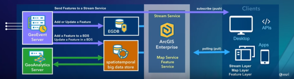
- Big Data Storage – Archive high-velocity data, with enhanced options for data retention. Effectively store all your big data in a geodatabase for further visualization of feature records.
- Visualization – Live stream feature services, on-the-fly feature aggregation, and work with live and historic aggregates and features. Visualize feature records with relational geodatabase feature services that support traditional RESTful web applications and APIs.
- Actuation – Notify devices in the field or third party data feeds that support a RESTful interface.
Real-time analytics allow for identification of event records with specified attribute values, as you can determine spatial relationships with established geofences. As spatial events occur, run on-the-fly processes ranging from disjoints, crosses, and intersects, to field calculators, buffer creators, and geotags.
The GeoEvent Server is fundamentally RESTful, accepting REST requests for data, as well as making REST requests on the outbound side. For example, when tracking mobile objects, get notified when a vehicle enters/exits a predetermined area. Create your own custom inputs through GeoEvent Manager or SDK (Java), or take advantage of the configurable out-of-the-box input connectors from GeoEvent Server.
- Poll an external web server or service
- Receive data records via HTTP/POST
- Receive data records via TCP/UDP socket
- Subscribe to an external web socket
- Watch a system folder for changes to a file
Leverage out-of-the-box output connectors from GeoEvent Server
- Add/update a feature
- Add/update a spatiotemporal big data store
- Send features to a stream service
- Push data records to an external website
- Push data records to an external websocket
- Send data records via TCP/UDP socket
- Send a text, email, or instant message
- Write a local file (CSV, JSON, GeoJSON)
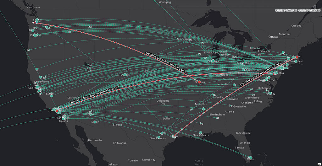
A plethora of output geoprocessing options (spatial filtering, buffer creator, difference creator, field calculator, geotagger, motion calculator) allow you to analyze your spatial data and learn from events to make more informed decisions for your organization.
With the web application GeoEvent Manager, you can designate inputs, outputs, and geoevents services. Also check out the ArcGIS GeoEvent Server Gallery to find the latest content including connectors, processors, tutorials, and apps. Streaming layers allow applications to stream services and immediately visualize observations, to consume data in real-time with no playback or storage requirements, and a low latency.
Get Support
Ready to integrate ArcGIS GeoEvent Server into your business strategy for real-time analytics and more informed decision making? Contact our experts at GeoMarvel to learn more and get started today.


