
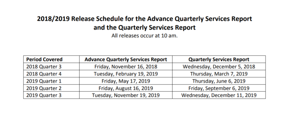
The 4th quarter of 2018 census data release occurs at 10 AM on Tuesday, February 19th, 2019. New data means new opportunities for spatial insight! Once the data is released, it’s time to contact our GIS experts for fresh insights on the new census data. Are you ready to start leveraging the power of GIS?
The 2020 US Census
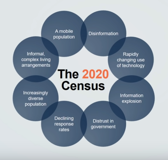
The United States Census Bureau has one of the largest GIS systems on the planet. The 2020 census is an enormous operation, with the goal of reaching every household to contact and count every person in the country. The main objective is to count everybody once, only once, and count them in the correct location. This effort will require virtual and in-person visits to locations all throughout the US. Conducting a census is clearly an undertaking, and it doesn’t come without challenges, from a growing mobile population, to the spread of disinformation in the modern world.
Paper Methods of the 2010 Census
Out with the old, and in with the new. The 2010 census survived on paper data. From paper forms and questionnaires, to enumerators tracking their hours and expenses on paper, enumerators visiting unresponsive households carried all their paperwork with them wherever they went. The Census Bureau printed 17 million paper map sheets, and over 50 million paper questionnaires. The 2020 census rethought the classic paper methods, and moved into the online realm.
The First Online US Census
The modernized 2020 census will invite people to complete forms online, instead of the traditional paper methods. Enumerators in the field will be given a phone for field work. All work assignments, surveys, expenses, and hours will be tracked and conducted via phone. Not only will these tactics reduce paper waste, but they’ll also lead to a 50% increase in productivity.
Geography is at the heart of all that the census bureau does. Working with state, local, tribal, and federal governments, the bureau maintains the most accurate and up-to-date geospatial information available. The Census Bureau is developing new tools designed to motivate people to respond to the upcoming 2020 census.
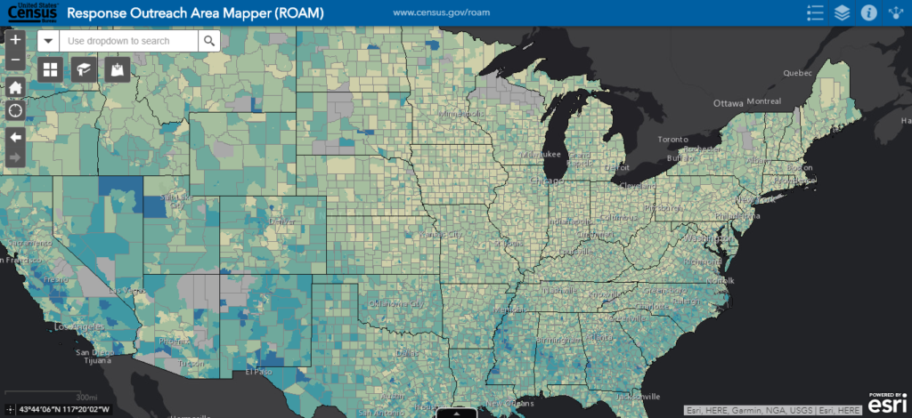
Response Outreach Area Mapper (ROAM)
ROAM is making it easier to figure out where and how to conduct outreach. This national map of census tracts that aids in locating areas of lower predicted self response rates. Each census tract offers more detail about the population and households, as ROAM is built with underlying American Community survey data. This easy mapping application is enabling census staff to make independent, well-informed, data-driven decisions.
Reinvented Field Operations
With the entirely new approach to the 2020 census, field operations have also shifted to exist online. Field workers can provide weekly availability, fill out forms, and track hours and miles completely online. Every step is mobile-enabled.
The online format of the census also comes with modern benefits.
- Faster data collection and submission
- Reduced use of paper
- Eliminated need for daily meetings with supervisor
- Reduce number of census takers by ⅓
- Reduce number of local census offices by ½
Get Support
Are you ready for the upcoming census data from 2018 and beyond? Capitalize on this fresh data with geospatial insight from GeoMarvel. Discover the power of GIS, reach out to our big data GIS experts to start a conversation today.


