
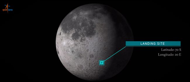
Explore our 3D moon scene highlighting India’s lunar landing site!
India’s lunar mission was just launched, sending their first lunar lander bound for the moon and striving to become the fourth nation to successfully land on the lunar surface. A successful landing means India will have accomplished what only China, Russia, and the United States have done before them.
India’s Lunar Mission
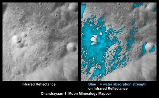
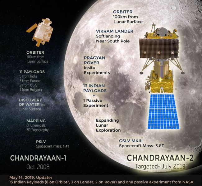
This mission is a follow up to the Chandrayaan-1, which was India’s first robotic mission to the Moon. Launched in 2008, Chandrayaan-1 set a spacecraft in orbit around the Moon, and made significant discoveries that helped scientists confirm that water ice exists near the Moon’s south pole. But with exact water ice amounts still undetermined, Chandrayaan-2 sets out to further answer the question.
The goal of the Chandrayaan-2 mission is to place a lander and rover on the lunar surface and conduct surface activities for a full lunar day, the equivalent of 14 Earth days. The plan is for the rover to get an up close view of the Moon’s south pole, to get a better estimate of the amount of water ice present.
Confirming quantities of water ice on the lunar surface is critical information for the future of lunar exploration, as the ice could be mined for drinking water and fuel for local spacecraft.
“It is the beginning of a historical journey of India towards the Moon and to land at a place near the south pole,” Kailasavadivoo Sivan, the chairman of the Indian Space Research Organization (ISRO), said during a speech after the launch, “To carry out scientific experiments; to explore the unexplored.”
Chandrayaan-2 Mission
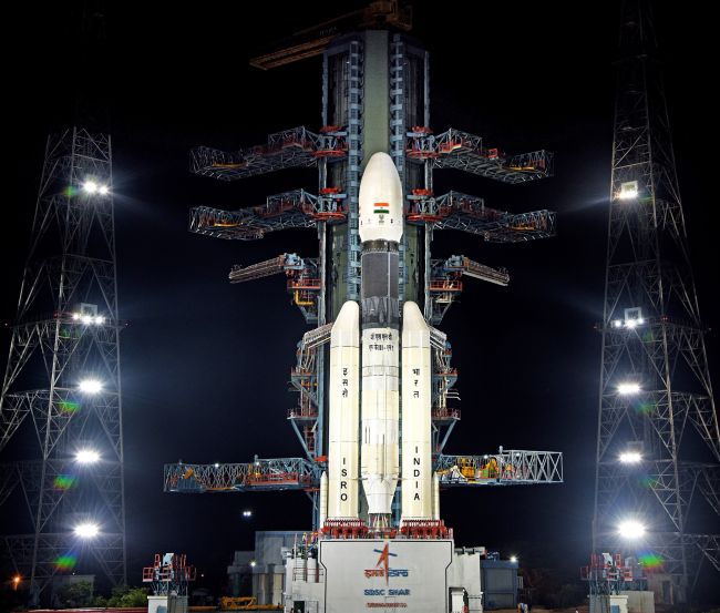
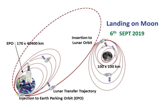
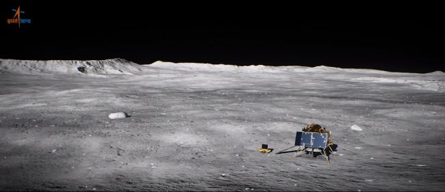
The GSLV MK-III rocket was launched on July 22nd. Chandrayaan-2 will orbit Earth for the next few weeks before heading toward the Moon. After roughly a month of orbit around the Moon, a lander (Vikram) and rover (Pragyan) will be sent to land near the south pole on the lunar surface on September 6th. The duo will touch down on a plain between the craters Manzinus C and Simpelius N, roughly 70 degrees south of the lunar equator.
The lander and Pragyan rover will be operational for two weeks following successful landing on the Moon, during this time they’ll study the landing site area with an array of onboard equipment to learn more about the composition of the surface, take temperature readings, and to monitor any Moonquakes that may occur. The Pragyan rover will have the ability to explore up to 500 meters away from its original landing site. Boasting a suite of on-board equipment, the rover will be able to…
- Search for and measure moonquakes with an instrument for lunar seismic activity (ILSA)
- Explore thermal properties of the surface with Chandra’s surface thermophysical experiment (ChaSTE)
- Examine plasma density on the lunar surface with radio anatomy of moon bound hypersensitive ionosphere and atmosphere (RAMBHA-Langmuir Probe)
- Investigate the surface composition with a laser-induced breakdown spectroscope (LIBS) and an alpha particle x-ray spectrometer (APXS)
But once the lunar night sets in, both surface bots will cease to function, as they rely on solar energy for power. With the Sun out of view for a full two weeks, the temperatures will drop below -200 degrees F (-130 C), and at such temperatures it’s a stretch for the electronics to survive the cold. Some good news is that the orbiter’s mission will continue on, orbiting the moon with full functionality for up to a full year. The orbiter will continue to study and map the moon using on-board instruments including…
-
- Terrain mapping camera 2 (TMC-2), to map the lunar surface in 3D using two on-board cameras
- Collimated large array soft x-ray spectrometer (CLASS), to map minerals on the lunar surface
- Solar x-ray monitor (XSM), for a closer look at emissions of solar x-rays
- Chandra’s atmospheric composition explorer (ChACE-2), which is a neutral mass spectrometer
- Synthetic aperture radar (SAR), which will map the surface in radio waves
- Imaging infra-red spectrometer (IIRS), to measure the amounts of water/hydroxl on the surface
- Orbiter high resolution camera (OHRC) to examine the surface and landing site for the lander and rover
Learn more about India’s lunar mission details here.
Future Moon Exploration
The benefits of the Chandrayaan-2 mission could be monumental, as many countries and companies are hoping to explore the moon in the years to come. NASA is focused on sending humans back to the moon, specifically to the south pole, where many US companies are planning to send robotic vehicles to mine for potential resources. The Chandrayaan-2 mission could lay down the foundation for future exploration of the lunar south pole.
Video from Space.com
“Through this effort, the aim is to improve our understanding of the moon – discoveries that will benefit India and humanity as a whole,” ISRO officials wrote in a description of Chandrayaan-2. “These insights and experiences aim at a paradigm shift in how lunar expeditions are approached for years to come – propelling further voyages into the farthest frontiers.”
Get Support
Missions like India’s Chandrayaan-2 mission require precious geospatial accuracy to accomplish. Exploring and mapping the moon will reveal new insights that may be helpful for the future of lunar exploration and site selection. GIS is a fundamental tool to explore the unexplored, and to venture where no other has gone before.
Reach out to our GIS industry experts to start a conversation about your unique GIS needs today. GeoMarvel wields over 20 years of industry expertise, and offers a wide range of professional geospatial services to answer all your GIS needs. To learn more about GeoMarvel’s past successes, check out our diverse portfolio here.


