
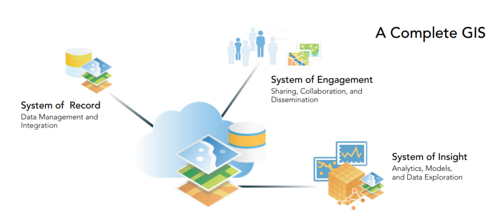
A complete GIS system for water utilities supports business needs through a system of record to build a model of real-world assets, a system of engagement to provide clear information to stakeholders, and a system of insight to learn from location-based analytics.
The ArcGIS platform is a complete GIS system. With integrated data and advanced analytics, this system maintains key information, analyzing the data and sharing it throughout the company – that’s business intelligence. Many issues that occur for a water utilities company all have one thing in common – location.
- Where are leaks occurring?
- Where is the network aging/vulnerable?
- Where is customer demand higher/lower?
These location-based inquiries are quickly addressed with a map, which can evolve a simple spreadsheet into an engaging map that provides an understanding of situations and patterns.
The complete GIS should include…
- A system of record for data management and integration
- A system of engagement for sharing, collaboration and dissemination
- A system of insight for analytics, modeling, and data exploration
System of Record
GIS can be viewed as a system of record, to record and monitor the location of assets. This authoritative source of information can be updated on-the-fly to represent any changes or updates to the system’s assets. Leveraging GIS as a system of record provides everyone throughout the organization with the same version of the data and assets.
System of Engagement
A system of record holds more value when the information is shared. This enables company-wide access to view and comprehend the data. Communication is key to effective engagement. Connecting people with location-aware devices promotes real-time situational awareness for an organization. Not only will this empower an organization’s employees, but also their stakeholders and customers.
When fieldworkers have the power to update maps, they’re continuing to drive and improve the system of record. Real-time field updates means there’s no more lost or delayed field notes written on scratch paper.
The ArcGIS platform supports efficient field data collection, smart mapping, location tracking, spatial analytics, and real-time situational awareness.
System of Insight
A system of insight can drive business value, with comprehensive analysis that reveals hidden trends in the data. The ArcGIS platform offers insights pulled from web sources and IoT sensors. Data collected may include real-time weather, traffic, and vehicle locations. Paired with spatial analysis, machine learning, big data analytics, and image processing, these insights can truly shape business intelligence by detecting patterns and correlations in the data.
The Complete GIS
GIS has more to offer than maps, ArcGIS is a complete GIS with a system of record, engagement, and insight, all of which provide an information system that creates value throughout the company.
Water utilities around the globe are investing in GIS systems. These provide location and situational awareness, and a complete system of record, engagement, and insight, allowing them to thrive in the modern digital world.
GIS in Water Utilities
See how other water utilities are leveraging the ArcGIS platform – a complete GIS system.
Esri’s Water Outage Solution for Utilities: How Utilities Can Effectively Manage Water Main Break Challenges
When it comes to water leaks, location is everything. Before you can effectively fix the problem, you must know WHERE the problem is.
Get Support
GeoMarvel can help your organization get your complete GIS system up and running with an ArcGIS Enterprise Jumpstart. Or build up your organization’s online portal with our ArcGIS Web Launch Kit. Already have a complete GIS system? Browse our professional service offerings to see how GeoMarvel can help your organization’s next big project.
Ready to get started? Reach out to our GIS development experts to start a conversation today.


