
Living Atlas
Two new apps have been added to the Living Atlas website.
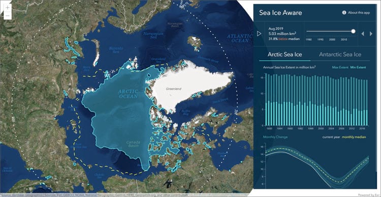
Sea Ice Aware highlights Arctic and Antarctic sea ice extents dating back to the 1970’s. This app shows the monthly mean of sea ice extent for each area, along with the historical median extent. Sea ice aware comes with built in graphs portraying the minimum and maximum extent for each year, along with a monthly time series for each year.
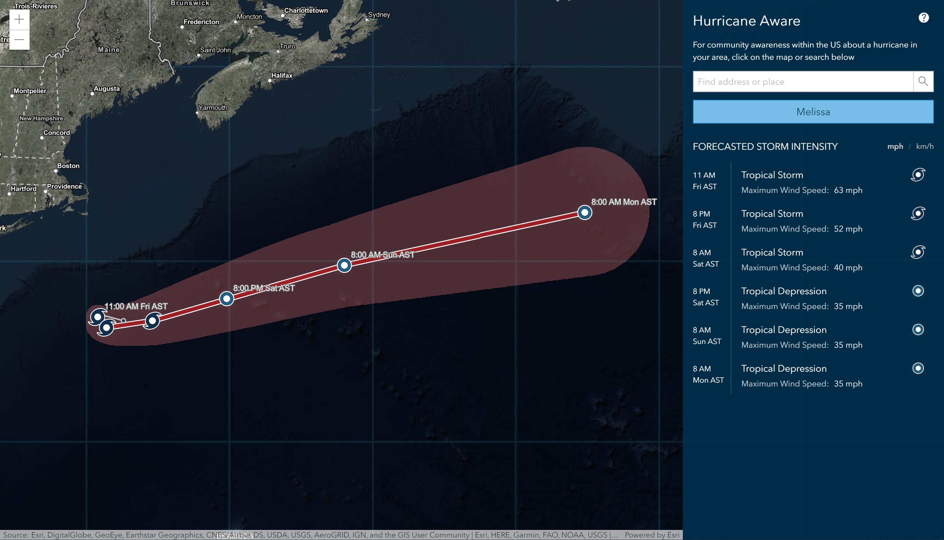
Hurricane aware is another new app that gives important information regarding potential tropical storm impacts on US soil. Data is pulled from the Living Atlas and National Weather Service forecasts for hurricanes, precipitation, and wind gusts.
Configurable App: Nearby
Have you tried out the new configurable app Nearby? Check out our recent blog post highlighting this brand new configurable app.
Data Management
Arcade is an expression language leveraged throughout the ArcGIS platform. From simple scripts to longer expressions, Arcade provides the syntax necessary to interact with your data.
Arcade has been upgraded with 4 new features
- GroupBy – group features in a feature set by a chosen field, returning statistics for each group.
- DistanceGeodetic – a tool used to calculate the shortest distance between two points along a great circle.
- FeatureSetByRelationshipName – this feature simplifies accessing features from layers that have relationships.
- FeatureSetByPortalItem – this feature allows you to create pop-ups rich with data from any layer in the Living Atlas or ArcGIS Online, without having to add each layer to the map, by simply using the layer’s Item ID to bring in the data.
Mapping and Visualization
Map Viewer Beta
Map viewer beta (the next generation of Map viewer) is in development, but is expected to be released soon. It’s encouraged to start working with Map viewer beta and provide your valuable feedback to esri regarding the design and functionality. See more about Map viewer beta here.
Scene viewer also has new updates and capabilities:
- Leverage the new scale range slider to define the visibility range of layers in a scene.
- Have your scene alternate between various layers as users zoom into the map.
- Display countries at a large scale, and filter down through regions, states, and counties and you zoom in.
- Display pop-ups on point cloud scene layers, where any given point can be selected to display its properties.
- 3D content now has better definition, with newly added lighting and shading models that create better contrast when you choose Quality in the settings tool.
- 3D buildings have been upgraded with better rendering for transparency settings.
- Upgrades to rendering allow scene layers to load twice as fast when navigating scenes.
Spatial analysis
Analyzing your data helps shed light on important patterns and relationships within the data. Let’s explore the latest spatial analysis updates.
Drive-time Areas
Create drive-time areas has three new parameters that have enhanced capabilities when leveraging drive-time areas.
- Choose the direction of travel for your drive-time areas.
- Are the drive times traveling away from your locations or towards them?
- Create drive-time area holes when an area is unreachable.
- Include reachable streets within drive-time areas.
- This will generate an output layer including the streets used to create the drive-time areas.
Connect Origins to Destinations
Measure the travel time or distance between pairs of points with the connect origins to destinations tool. Report straight distances, trip duration and distances based on travel mode, like walking, biking, or driving.
Follow Streets
Leverage street files with Follow Streets to create routes between origins and destinations that follow streets to get from point A to point B.
Straight Line Tool
Create spider diagrams or desire lines with the Straight line tool for straight line connections. Leverage the ArcGIS GeoEnrichment Service to enrich point, line and polygon locations with demographic and landscape data.
New & Updated Content
- USA NLCD impervious surface time series depicts urban impervious surfaces as a percentage of developed surface over every 30-meter pixel in the US from 2001-2016.
- Updated list of critical habitat layers – view all habitat layers here.
- New layers added from the World Database on Protected Areas (WDPA). This is the most comprehensive global database on terrestrial and marine protected areas.
- Updated layers for USA federal lands including USA Federal Lands, USA Fish and Wildlife Service Lands, USA Forest Service Lands, USA National Park Service Lands, and USA Bureau of Land Management Lands.
- Now in beta – check out the Oceans Hybrid Coordinate Ocean Model (HYCOM).
- Discover updates to demographic maps in countries around the world.
Get Support
Are you ready to leverage the power of ArcGIS Online? Get your web GIS off the ground with our ArcGIS Web Launch Kit.
Seeking other professional GIS services? Explore our vast portfolio, and reach out to our GIS development experts to start a conversation about your unique GIS needs today.


