
Tracker for ArcGIS is Now Available in ArcGIS Online
Tracker for ArcGIS is now available as an organizational extension in ArcGIS Online! The location tracking application provides a new way to track and store the locations of all your mobile assets. Haven’t heard about Tracker for ArcGIS yet? Get caught up with our first blog on this location tracking application here.
Passively tracking locations on-the-go has never been easier. Tracker for ArcGIS stores your recorded tracks within your organization for up to 30 days, with no feature storage or credit costs. Need to keep records for longer than a month? Easily export the location tracking layer for longer term storage of this valuable data.
An extension for ArcGIS Online, Location Tracking enables you to record the tracks of users from your organization. By enabling Location Tracking, you’ll empower organizational users to leverage the Tracker Mobile App to record and upload their locations to the securely stored location tracking layer. By default, users can only see their own tracks, but additional permissions are easily enabled to view the tracks of other users within your organization.
Take advantage of the location tracking layer for your organization in two ways: via the Track Viewer web app or with the Tracker for ArcGIS mobile app.
Track Viewer Web App
Before leveraging the Track Viewer web app, learn more about viewing tracks in Track Viewer here. You can add mobile users manually to track views, via a CSV file, or you can add members from a group or Workforce for ArcGIS project. Track Viewer is the key to share this data safely and securely with others, and allows for easy visualization of recorded tracks within your organization.
The Track Viewer web app enables administrators to define which user locations are tracked, with filtering capabilities to view only the tracks you’re interested in analyzing. Filter by users, specific time spans, GPS accuracy, a given speed range, or by the type of activity that occurred during data collection.
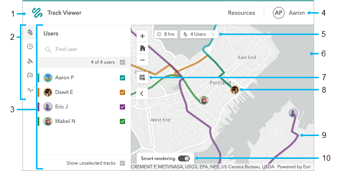
Esri’s quick reference guide for Track Viewer provides an easy rundown of the available features and filters to learn all about the tracks within your organization.
- View all available tracks in your organization.
- Find all your available filters.
- This panel can be configured to show which filters appear on the map view.
- Profile of the signed in user.
- Active filters will be displayed here (clicking the “X” will clear the active filter).
- Map portraying collected track data.
- Basemap switcher.
- The last known location of each user, which displays their user profile picture.
- User tracks, which can be clicked for further details including the track owner, device’s battery level, their last known speed and activity type, which direction they were heading, and the GPS accuracy for their last known track point.
- Smart rendering can be toggled on to restrict track lines to meet specific criteria.
Tracker for ArcGIS Mobile App
The mobile application is built with the end user in mind. The app can record tracks in the background, has a minimal impact on device battery life, and can record via the device’s GPS location whether the user maintains a data connection or not. Additionally, users have full control over when and where their tracks will be recorded.
This premium application can be leveraged by Android and iOS devices alike, empowering you to record and share exactly where all your employees have traveled throughout the day. The latest updates give you the ability to switch basemaps while viewing tracks, optionally switch things to dark mode, and launch the camera for QR code scanning (when signing into ArcGIS Enterprise). To see all requirements surrounding Tracker for ArcGIS, browse through the informative FAQ page.
The Roadmap for 2020
In the near future, the tracks you record with Tracker for ArcGIS will have the capability to sync with other ArcGIS field apps like Collector for ArcGIS and Explorer for ArcGIS. You’ll have more control over location tracking with advanced scheduling, support for indoor positioning, geofencing capabilities, Apple Watch support and the ability to extend the location tracking schema.
Esri encourages feedback on the growing functionality of Tracker for ArcGIS. Hop over to their Geonet site to continue the discussion on this powerful ArcGIS application. Have a great idea for the advancement of Tracker for ArcGIS? Post your idea to the ArcGIS Ideas page.
Get Support
New to the ArcGIS platform? Get started with our Web Launch Kit or ArcGIS Jumpstart services to get your GIS off the ground quickly. In need of custom GIS solutions for your organization? Reach out to our GIS industry experts to start a conversation about your unique GIS needs today.


