
GeoMarvel recently partnered with the Cadasta Foundation to deploy ArcGIS Enterprise 10.8.1. The Cadasta Foundation’s mission is to document land and resources in the undeveloped world in order to secure land rights and security for all. To accomplish this mission, Cadasta needed to deploy ArcGIS Enterprise in their headquarters in Northern Virginia and in the field in Mumbai.
This deployment was the next step for Cadasta’s computing life cycle, and gave them more capabilities for their mission of documenting and creating universal access to land rights information. GeoMarvel began this process with our ArcGIS Enterprise Jumpstart package, which includes an assessment of the Foundation’s technological needs, development of a customized framework and infrastructure to fit their multi-regional needs, and the deployment of ArcGIS Enterprise configured their AWS account for premium cloud hosting.


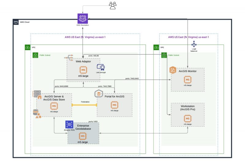
Because the Cadasta Foundation had unique regional requirements, GeoMarvel took the time to develop and implement a customized cloud architecture that efficiently allowed members in Virginia and Mumbai to have access to the specific tools and services they needed to leverage while still leveraging the same cloud environment.
Partnering with GeoMarvel has allowed the Cadasta Foundation to level up their mapping abilities through a cloud-based approach to GIS. They can now leverage ArcGIS Enterprise for many things, including On The Fly image processing, geoprocessing, print tools, and image caching, allowing Cadasta to be an advanced producer of high-quality GIS content, data and maps.
GeoMarvel continues to support the Cadasta Foundation through our Managed Services package, which has allowed us to upgrade their Enterprise to 10.8.1, and allows for continued support of their GIS cloud infrastructure, security, and future upgrades needs.
Leveraging these technical capabilities is the future for them to continue to be a predominant foundation, while continuing to grow and improve their services. They are now able to offer customers “the most powerful mapping and spatial data analytics technology available.”
Is your organization ready for an ArcGIS Enterprise Jumpstart to get your GIS capabilities up and running? Or perhaps you’re seeking other Professional GIS Services? Explore all of our professional services, and read up on our past successes outlined in our diverse portfolio. Reach out to our industry experts to start a conversation about your unique needs today.


