
In a recent collaboration, GeoMarvel partnered with Televate, a public safety and technology consulting firm specializing in interoperable communications infrastructure. The core focus was on their Pinpoint project. Pinpoint is a coverage collection and analysis service that enables users to crowdsource cellular network availability and performance data from various carriers including Verizon, T-Mobile, and AT&T.
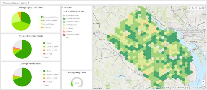
Image from Televate
Pinpoint empowers users to collect self-directed information about carrier coverage without the need for any special equipment. All you need is a smartphone and the Pinpoint app. Typical coverage maps provided by wireless carriers use a statistical average to predict service, but Pinpoint offers the empirical evidence of service levels, rather than merely a prediction.
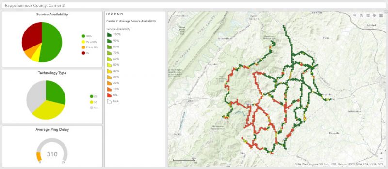
Image from Televate
The Pinpoint mobile application collects over 50 unique data elements including service availability, ping loss, ping delay, device location, signal strength, signal quality, network latency, and data throughput. As the Pinpoint app collects data in Background Mode, users can continue to use their phones like normal. The mobile application integrates with Televate’s geospatial cloud service to aggregate, analyze, and provide high quality data visualizations for their end users.
The Pinpoint mobile application was built to leverage Esri technologies, along with a geospatial cloud infrastructure, enabling effective post-processing, analysis, and on-the-fly data visualization of carrier coverages. Pinpoint leverages a suite of Esri and cloud technologies, including ArcGIS Enterprise, the ArcGIS API for Python, ArcPy, an AWS cloud infrastructure, Lambda, CloudFront, API Gateway and Amazon Relational Database Service RDS.
Powered by the geospatial cloud, GeoMarvel supports Televate’s mission to offer comprehensive client-side data visualizations for their customers. With the Pinpoint dashboard, a range of gathered information can be shared at-a-glance.
GeoMarvel is proud to collaborate with Televate in this venture to provide high quality data visualizations of carrier coverage to the Public Safety Community. With a geospatial cloud infrastructure coupled with a comprehensive network carrier analysis, Pinpoint presents a fresh and innovative method for delivering a complete view of network carrier coverage. For further insight on the Pinpoint project click here.

Ready to leverage professional GIS services from GeoMarvel? Reach out to our industry experts to start a conversation about your unique GIS needs today!


